Monday, October 26, 2009

Sunday October 25, 2009 PEAK LEAVES PEAK CROWDS

Sunday, October 25, 2009
GREAT LEAF COLOR +
GREAT WEATHER +
WEEKEND DAY = HUGE CROWDS

EXTRA EXTRA EXTRA
NEW PRIVY AT OLD RAG SHELTER
PICTURES ON FUTURE BLOG POST!


Old Rag from the road before the lower lot if you had a telescope you could see the crowds streaming up the trail.

NO PETS ALLOWED TM APPLIED FOR
This title may be used for a future electronic game in which hapless Keystone Cop like volunteers are pitted against supremely wily, passionate and resourceful pet owners.

Gotta love em!


The fee station staff was kept busy today.

A couple of hiking groups headed up the road to the trail head.
"No snowflake in an avalanche ever feels responsible." —George Burns.


Most groups enjoy a refreshing pause at the spot shown in the next picture.
.
There is no camping allowed between this spot on the Ridge Trail at about 2,400 feet and Byrd's Nest Shelter at about 2,800 feet on the Saddle Trail.
.

Old Rag contains some very fragile micro-habitats. Old Rag is like an island in the sky. Many plants located here do not exist again until you get hundreds of miles from Old Rag. Like remote islands there are even species and or sub-species that are unique just to Old Rag's micro-habitat. Once destroyed there is no way for them to be re-established.

Steward Ben during one of our frequent life is good moments.


Looking across Weakley Hollow towards Skyline Drive and the Appalachian Trail.


Lots and lots of hikers enjoying the day.


A zoomed shot of the Chute from the First False Summit.
.
The next picture was taken while waiting in a line which stretched a tenth of a mile to the Chute, 528.6 linear feet, 120 vertical feet, about six stories and two city blocks or from R28 to R31.
.
Note: If you expand the picture below you can see a hiker high up on the cliff face (one example of tens I saw this day) who was tired of waiting in line and was trying his luck at an alternative route. While there is no rule against this it is highly advised against. Going off trail you are trampling ground not routinely trampled upon. A fall will end with a literal impact on the resource. Non-ambulatory injuries put huge demands on the folks who need to respond.
.
I know many accomplished climbers whom I would not be nervous watching free solo these alternate routes. I would be confident that their practiced skills and deep experience allowed them to be Clipped-Into-Themselves -Pat Ament- . But on this day, most of those I saw attempting these alternate routes did not display any signs that they possessed the skill and experience to be relatively safe on their free solo adventures. Being too far away I was not in a good position to suggest they alter their behaviour.
.
There is a definite morbid fascination and pleasure I get from watching these individuals' mini-dramas (Patroller/Steward TV) but I eventually need to get on with my steward/patrol duties. After all, I will find out soon enough if I need to respond to something bad happening.
.
Don't worry be happy. In every life we have some trouble. When you worry you make it double. -Bobby McFerrin-
.
EXPECT CHANGES
Expect changes to ORMS over time. The Old Rag Mountain Steward program is still in its infancy. The topic of how ORMS can best perform its mission is under constant review. Lessons are constantly being learned and improvements are constantly being made. Do not make any assumptions or plans based on any of our past behaviours.
.
This is actually good advice for any of your visits to the outdoors. Go assuming your own self sufficiency. Do not assume the friendly fee station staff will give you a map. Come with your own map. Do not assume there will be extra water at the fee station make sure you have brought enough. Do not assume a friendly steward will be there to help. Stewards may not be on the mountain or may be fully occupied.
.
A HYPOTHETICAL FUTURE (Is that redundant?)
It is not that hard for me to imagine a far distant future in the which the trail has purposely been removed, all maps containing wilderness areas have been changed so they only show a large blank area labeled WILDERNESS, all guidebooks to wilderness areas have been banned, and it is against the rules to provide assistance of any kind to park visitors located in managed wilderness areas. (Is that an oxymoron?).
.
We do not carry injured bears out on a litter why should humans be any different? If wildlife could vote humans would be designated an invasive species.
.
-extracted from the majority opininion of a hypothetical Supreme Court Case-
(Is it magniloquent to pose as a hypothetical Supreme Court Judge, or what)

NEW PRIVY INSTALLED AT OLD RAG SHELTER PICTURES NEXT WEEK!

Saturday October 25, 2009 PATC TP Training

PATC Trail Patrol Training at Glasshouse
Saturday, October 24, 2006


Early Saturday morning a double rainbow over Front Royal observed on the way to Glasshouse which is near Elizabeths Furnace in the Massanuttens.


The inside of Glasshouse cozy but adequate space for a small group of students and instructors.

Training hike starts with a little practice with map and compass.

Scenario training.


More scenario training.


Monday, October 19, 2009

Wilderness Weekend Sun 10/18/2009

Wilderness Weekend LET IT SNOW
Sunday October 18, 2009

The PATC Trail Patrol Wilderness Weekend crew who stayed at Pinnacles Research Station Saturday Night awoke to the FIRST SNOW OF 2009. Today was one of those days when Skyline Drive was in Winter while the rest of the area including Old Rag was still experiencing Fall. Under 200 hikers on Old Rag today. During a more typical October weekend we would have over 1,000 hikers on Old Rag.


.
A rare blog picture of me in a Shenandoah Winter Wonderland.
.

While I did Wilderness Weekend outreach on Saturday today I was going to be doing an Old Rag Patrol. This is a sign at one of the Skyline Drive overlooks from which you can see Old Rag on a clear day.

.
.
This was the sign at the Thorton Gap entrance station.
.
.
Part way up the Old Rag Ridge Trail we ran into a little Red Spotted Newt
.
.
Looking up the Ridge from the first slab on the first false summit.
.
.
.
Looking up the Ridge Trail just before entering the rock scramble.

.
.
.
Looking up the rock scramble from above the cave but below the chute.
.
.
Stitch of Summit views.
.
.
Stitched photo of summit views.

Wilderness Weekend Sat 10/27/2009

Wilderness Weekend
Saturday October 17, 2009


Most of Old Rag's Ridge and Saddle trails lie within designated wilderness areas.

This was Wilderness Weekend and on Saturday PATC Trail Patrol members arrived at the Pinnacles Research Station and started their day making signs. After this they broke up into groups in order to cover Dickey Ridge, Skyland, and Big Meadows. Because of the weather the activities were moved inside this year. In good weather we set up at various overlooks. With my Old Rag obsession I did my outreach at the Old Rag fee station.

It is surprising the number of folks you meet who do not know about our designated wilderness areas.

The following is a great resource when you have questions about our designated wilderness areas.

http://www.wilderness.net/


Getting signs ready for Wilderness Weekend at Pinnacles Research Station.


My Old Rag Wilderness Weekend duty station.


SOME WILDERNESS BACKGROUND:

(CUT AND PASTED DIRECTLY FROM WILDERNESS.NET)


Creation and Growth of the National Wilderness Preservation SystemWhen the Wilderness Act was passed in 1964, 54 areas (9.1 million acres) in 13 states were designated as wilderness. This law established these areas as part of the National Wilderness Preservation System. Since 1964, the NWPS has grown almost every year and now includes 756 areas (109,492,591 acres) in 44 states and Puerto Rico. In 1980, the passage of the Alaska National Interest Lands Conservation Act (ANILCA) added over 56 million acres of wilderness to the system, the largest addition in a single year. 1984 marks the year when the most new wilderness areas were added. Think you know a lot about the NWPS? You can also test your knowledge by taking one of our quizzes.
Fast Facts at a Glance
Number of Wilderness Areas756 wilderness areas
Total Wilderness Acreage109,492,591 acres
Smallest WildernessPelican Island Wilderness, northern Florida (6 acres) (Note: Until recently the Rocks and Islands Wilderness in northern California was thought to be the smallest wilderness, however, recent Bureau of Land Management acreage measurements put it at 19 acres instead of 5 acres.)
Largest WildernessWrangell-Saint Elias Wilderness, Alaska (9,078,675 acres)
Largest Wilderness complex (contiguous Wilderness acreage)Noatak and Gates of the Arctic Wildernesses, Alaska (12,743,329 acres)
Largest Wilderness complex (contiguous Wilderness acreage) in the contiguous United StatesFrank Church-River of No Return and Gospel-Hump Wildernesses, Idaho (2,572,553 acres)
Second largest Wilderness complex (contiguous Wilderness acreage) in the contiguous United StatesWildernesses in central California consisting of the southern half of the Yosemite Wilderness and the Ansel Adams, Dinkey Lakes, John Muir, Monarch, Sequoia-Kings Canyon, Golden Trout, and South Sierra Wildernesses (2,241,439 acres)
States with the most WildernessesCalifornia, Arizona, Nevada, Alaska, Colorado
States with the most Wilderness acresAlaska, California, Arizona, Washington, Idaho
States with no WildernessesConnecticut, Delaware, Iowa, Kansas, Maryland, Rhode Island
Agency managing the most WildernessesForest Service
Agency managing the most Wilderness acresNational Park Service
Newest WildernessesOn 3/30/09 President Obama signed the Omnibus Public Land Management Act of 2009 (Public law 111-11) into law. This law designates 52 new wilderness areas and adds acreage to 26 existing areas, a total addition to the NWPS of over 2 million acres. Some, but not all, of these areas are pictured on Wilderness.net's maps. You can view a list of these areas with links to more infromation about them.
Trivia QuestionHow many designated Wildernesses does the Appalachian National Scenic Trail traverse? Answer: 21

Tuesday, October 13, 2009

Columbus Day PATC TP

Columbus Day 2009

Overcast and a little cool. A moss and lichen garden on the way up the Ridge Trail.


Looking up the Ridge Trial. Take a look at a similar shot from just a couple of weeks ago in order to see how fast the colors changed. It is unfortunate but very pretty wispy smoke like tendrils of fog where blowing left to right across this picture. I am not sure any still shot could catch them. It would probably take a very high quality video to capture them.

Looking out from the end of the igneous dyke at the start of the Ridge Trail rock scramble.


Looking back at the first false summit from below cave. If zoomed you can see a hiker on the top front taking a picture back towards the left or Skyline drive.


Looking out from the cave.


Leaf colors are getting near peak.


Monday, October 12, 2009

Sunday October 11, 2009 Rescue Leaves and Crowds

Old Rag

New Old Rag Mountain Stewards receive some training.

The fall crowds have arrived with the leaves changing color.


The next three shots are of the litter carry of a non-ambulatory patient from the middle of the chute up and over the summit to a National Park Service SAR vehicle at Old Rag Shelter.
Note: For hikers who come to the mountain only prepared for a quick hike if you are non-ambulatory it is going to take awhile to get you out especially if your injury occurs in the middle of the rock scramble. On this day the patient was loaded into the ambulance around 11PM. Given the nature and place of injury this was actually a smooth and fast extraction. Yes helicopter extractions can sometimes be done but most often they either can not or should not be done. Obviously Old Rag is not as remote as a multi-pitch technical climb at the end of a fifteen hour approach hike but do not be lulled into treating it like a walk in a city park either.


Monday, October 5, 2009

ORMS BACK ON MOUNTAIN 10/4/2009

ORMS is back on the mountain until the second weekend in November. The fledgling ORMS continues to grow, on Sunday we had nine Stewards on the mountain. On Saturday there had been a different group of volunteers patrolling. Two of Saturday's volunteers had stayed overnight in the backcountry. They started their patrols high on the mountain early Sunday morning. We can usually be identified by our signature orange tee shirts.

WHAT IS ORMS

ORMS is short for Old Rag Mountain Stewards. Our primary mission is resource protection. ROCKS, PLANTS, ANIMALS. As part of our resource protection mission we provide visitor services including; education, outreach, information, interpretation, basic first aid, emergency first response, Park communications, and SAR services. Shenandoah National Park sponsored our creation as a preferred method of limiting visitor impact on the natural resources of Old Rag(Raggedy) Mountain. The Park picked the outdoor adventure/team building organizations of Teamlink/Shenandoah Mountain Guides to assist the Park establish the Old Rag Mountain Steward program. ORMS welcomes new volunteers.

A fact sheet on the program can be found at:
http://mms.nps.gov/shen/ncr/docs/factsheets/SHEN_BC_070_Old_Rag_Mountain_Steward_Program.pdf

There are also links to both the ORMS's blog and Shenandoah Mountain Guides' blog in the My Blog List section of this blog.

I wanted to ask you to do one thing in connection with it.
.
In your own interest and in the interest of the Country. Keep this great wonder of nature as it now as.
.
Leave it as it is. You can not improve it. The ages have been at work on it and man can only mar it.
.
What you can do is to keep it for your children, your childrens' children and for all who come after you.
-Theodore Roosevelt (An excerpt from a speech given at the Grand Canyon.)

The following picture shows a group of ORMS volunteers getting ready to split up so as to patrol up both sides of Old Rag mountain. We enjoy providing information and look forward to your questions.

Some interesting mushrooms sprouting from the large blowdown featured in the blog entries for the two weekends prior to this.
I saw lots of these fuzzy white caterpillars with black spike hairs on the way up the Ridge Trail switch backs. They are white American Dagger Moth Caterpillars.


The first false summit is a worthy destination all by itself.
.
The next four pictures were taken from various spots on the first false summit. I have a label in my label list which if click on will bring up many blog entries with pictures of or from the first false summit. The first false summit is an approximately 2.8 mile and 2,000 foot elevation gain hike from the lower parking lot. There are only two easy rock problems that need to be navigated to get to the first false summit. The harder rock problems do not occur until the official rock scramble starts at R22 when you leave the first false summit on the way up the Ridge Trail. The first false summit consists of a massive granite formation that sticks up a couple hundred feet on the Ridge Trail and has 360 degree views. If the rest of Old Rag did not exist this granite peak would still be one of the favorite hikes within the Park.
.
OLD RAG DOGS
The picture below contains Old Rag Dogs. These dogs live in one of the homes at the base of the mountain. They come up on the mountain by themselves (go walk about) and know how to get home on their own. They sometimes randomly hook up with various hiking groups. Pets are not allowed with hikers on Old Rag but I think these can be considered local domesticated fauna. They can appear to be abandoned and in desperate condition when they are actually fine. Two are very friendly but one is very shy. Being outdoor dogs, do not be surprised if they have found a way to get a little dirty or smelly. Their owners care a lot about them. Their current tags have messages letting hikers know they can find their way home.
.

Looking East North East towards Etlan, Syria, Woodville.

Looking West towards Skyline Drive and the Appalachian Trail
Note: This panorama is stitched together from three shots. Most of my blog pictures offer higher resolution if you double click and use slider bar.

Looking SouthWest up the Ridge Trail.
Note: Stitched together vertically. Color change on the rock is an artifact from stitching two photos together.

Looking up the Ridge Trail from the first slab on the first false summit. If zoomed you can see some of the vultures that like to soar around Old Rag.


A very pretty cluster of pink flowers growing from a rock crevice high on the mountain. I believe that this is some type of wild Sedum AKA Stonecrop.


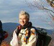
A hiker enjoying the view from one of the summit boulders.


Trees were mostly still green but there was a little more color than last weekend and many trees looked like they were on the verge of changing.